
CRISP Project
  • Home
  • Description
  • Consortium
  • News & Events
    • Final Workshop
    • Der Standard Story
  • Menu Menu

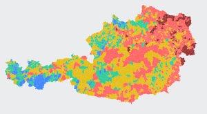
Interaktive Karte zeigt, welche Bezirke in Österreich die höchste Hitzebelastung haben

Die Kombination aus mehr Hitzetagen und alternder Bevölkerung macht vielen Regionen zu schaffen. Ohne größere Maßnahmen für weniger CO2 ist bis 2050 fast jeder Bezirk “sehr hoch” belastet

14. August 2024, 12:34
More information.

  • Der Standard story
  • Final Workshop
Search Search
Funded by the Austrian Federal Ministry for Climate Action, Environment, Energy, Mobility and Technology (BMK) via the ICT of the Future Program - FFG No 887554

BMVIT FFG Logo
CRISP – Crisis Response and Intervention Supported by Semantic Data Pooling
Scroll to top Scroll to top Scroll to top